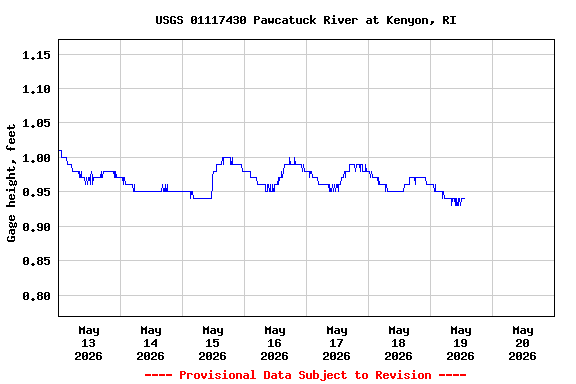
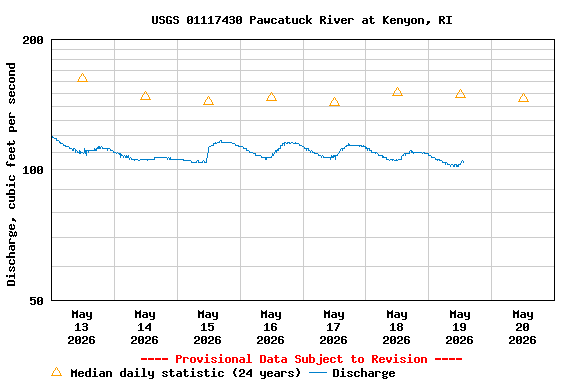
USGS 01117430 PAWCATUCK RIVER AT KENYON, RI

PROVISIONAL DATA SUBJECT TO REVISION

Click to hidestation-specific text

Station operated in cooperation with the Rhode Island Department of Environmental Management.

Boating safety tips
Available Parameters Available Period
  
2002-08-06  2026-01-22
2007-10-01  2026-01-22


 (7)
 

  -- or --


Summary of all available data for this site
Instantaneous-data availability statement


Discharge, cubic feet per second

Most recent instantaneous value: 46.5 01-22-2026   10:15 EST
Graph of  Discharge, cubic feet per second

Add up to 2 more sites and replot for "Discharge, cubic feet per second"

?


Create presentation-quality / stand-alone graph.   Subscribe to WaterAlert      

See this graph on the Monitoring Location Pages


Daily discharge, cubic feet per second -- statistics for Jan 22 based on 23 water years of record more
Most Recent
Instantaneous
Value Jan 22
Min
(2008)
25th
percen-
tile
Median Mean 75th
percen-
tile
Max
(2019)
46.5 80.2 120 149 181 189 400


Gage height, feet

Most recent instantaneous value: 0.74 01-22-2026   10:15 EST
Graph of  Gage height, feet

Add up to 2 more sites and replot for "Gage height, feet"

?


Create presentation-quality / stand-alone graph.   Subscribe to WaterAlert      

See this graph on the Monitoring Location Pages