USGS 05451210 South Fork Iowa River NE of New Providence, IA

PROVISIONAL DATA SUBJECT TO REVISION

Click to hidestation-specific text

> Site Information

> National Weather Service River Forecast

> Images

Funding For This Site Provided By:

Link to Upstream Gage

Iowa WSC Gage Network

Link to Downstream Gage


This station managed by the Fort Dodge Field Office.

Available Parameters Available Period
  
2007-10-01  2011-11-28
2007-10-01  2008-09-30
1995-10-26  2024-06-13
2007-10-01  2024-06-13
2007-10-01  2011-11-28
2007-10-01  2011-11-28
2013-05-14  2013-11-17
2007-10-01  2011-11-28
2013-05-14  2013-11-17
2013-05-14  2013-11-17
2010-04-23  2011-11-28
2013-05-14  2013-11-17
2010-07-30  2011-11-28


 (7)
 

  -- or --


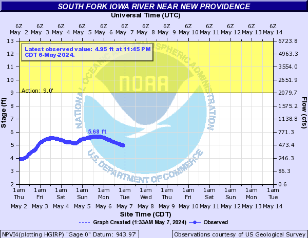
Summary of all available data for this site
Instantaneous-data availability statement


Discharge, cubic feet per second

Most recent instantaneous value: 40.2 06-13-2024   15:45 CDT
Graph of  Discharge, cubic feet per second

Add up to 2 more sites and replot for "Discharge, cubic feet per second"

?


Create presentation-quality / stand-alone graph.   Subscribe to WaterAlert      

See this graph on the Monitoring Location Pages


Daily discharge, cubic feet per second -- statistics for Jun 13 based on 28 water years of record more
Min
(2021)
Most Recent
Instantaneous
Value Jun 13
25th
percen-
tile
Median 75th
percen-
tile
Mean Max
(2008)
21.4 40.2 106 216 308 393 3120


Gage height, feet

Most recent instantaneous value: 3.30 06-13-2024   15:45 CDT
Graph of  Gage height, feet

Add up to 2 more sites and replot for "Gage height, feet"

?


Create presentation-quality / stand-alone graph.   Subscribe to WaterAlert      

See this graph on the Monitoring Location Pages