PROVISIONAL DATA SUBJECT TO REVISION
Click to hidestation-specific text
 Site Information
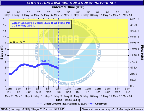
Summary of all available data for this site
Instantaneous-data availability statement
Temperature, water, degrees Celsius |
||
|
||
Precipitation, total, inches |
||
|
||

| Min (2021) | 25th percen- tile | Median | 75th percen- tile | Most Recent Instantaneous Value Aug 2 | Mean | Max (2010) |
|---|---|---|---|---|---|---|
| 2.02 | 20 | 31 | 45 | 47.7 | 81 | 885 |

Specific conductance, water, unfiltered, microsiemens per centimeter at 25 degrees Celsius |
||
|
||
Dissolved oxygen, water, unfiltered, milligrams per liter |
||
|
||
Dissolved oxygen, water, unfiltered, percent of saturation |
||
|
||
pH, water, unfiltered, field, standard units |
||
|
||
Dissolved organic matter fluorescence (fDOM), water, in situ, concentration estimated from reference material, micrograms per liter as quinine sulfate equivalents (QSE) |
||
|
||
Chlorophyll, total, water, fluorometric, 650-700 nanometers, in situ sensor, micrograms per liter |
||
|
||
Turbidity, water, unfiltered, broad band light source (400-680 nm), detection angle 90 +-30 degrees to incident light, nephelometric turbidity units (NTU) |
||
|
||
Turbidity, water, unfiltered, monochrome near infra-red LED light, 780-900 nm, detection angle 90 +-2.5 degrees, formazin nephelometric units (FNU) |
||
|
||
Nitrate plus nitrite, water, in situ, milligrams per liter as nitrogen |
||
|
||
![]() U.S. Department of the Interior |
U.S. Geological Survey
U.S. Department of the Interior |
U.S. Geological Survey
Title: USGS Current Conditions for Iowa
URL:
Page Contact Information: Iowa Water Data Support Team
Page Last Modified: 2026-08-02 09:34:33 EDT
7.3 5.56 sdww02