LOCATION.--Lat 42°18'54.3", long 93°09'07.4"
referenced to North American Datum of 1983, in SE 1/4 NW 1/4 SW 1/4
sec.26, T.87 N., R.20 W., Hardin County, IA, Hydrologic Unit
07080207, on left bank 15 ft downstream from bridge on R Avenue, 2.0
mi northeast of New Providence, and 4.0 mi upstream from confluence
with the Iowa River. (map)
DRAINAGE AREA.--224 mi2.
SURFACE-WATER RECORDS
PERIOD OF RECORD.--Discharge records from October 1995 to current
year.
REVISED RECORDS.--WDR US-2007: Location, Datum. WDR US-2010:
Datum.
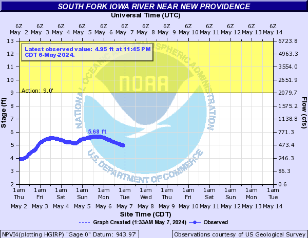
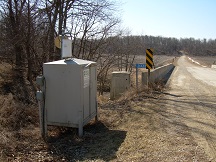
GAGE.--Water-stage recorder. Datum of gage is 943.97 ft above
National Geodetic Vertical Datum of 1929.
CLIMATOLOGICAL RECORDS
PERIOD OF RECORD.--October 1995 to September 2008.
INSTRUMENTATION.--Tipping bucket rain gage.
WATER-QUALITY RECORDS
PERIOD OF RECORD.--Water years 1996-2012.
PERIOD OF DAILY RECORD.--
SPECIFIC CONDUCTANCE: October 2005 to September 2008, April 2010 to
November 2011, records fragmentary.
WATER TEMPERATURE: October 2005 to September 2008, April 2010 to
November 2011, records fragmentary.
DISSOLVED OXYGEN: October 2005 to September 2008, April 2010 to
November 2011, records fragmentary.
pH: October 2005 to September 2008, April 2010 to November 2011,
records fragmentary.
TURBIDITY: April 2010 to November 2011, records fragmentary.
NITRATE PLUS NITRITE: July 2010 to November 2011, records
fragmentary.
 Site Information