USGS 05465100 Iowa River at Columbus Junction, IA

PROVISIONAL DATA SUBJECT TO REVISION

Available Parameters Available Period
  
2021-07-13  2026-02-23
2021-07-11  2026-02-23


 (7)
 

  -- or --


Summary of all available data for this site
Instantaneous-data availability statement


Discharge, cubic feet per second

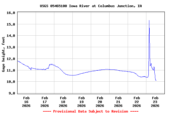
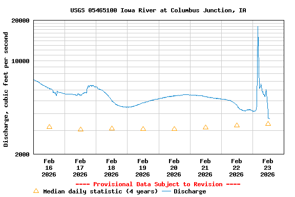
Most recent instantaneous value: 3810 02-23-2026   22:00 CST
Graph of  Discharge, cubic feet per second

Add up to 2 more sites and replot for "Discharge, cubic feet per second"

?


Create presentation-quality / stand-alone graph.   Subscribe to WaterAlert      

See this graph on the Monitoring Location Pages


Daily discharge, cubic feet per second -- statistics for Feb 23 based on 4 water years of record more
Min
(2024)
25th
percen-
tile
Median Most Recent
Instantaneous
Value Feb 23
Mean 75th
percen-
tile
Max
(2023)
1970 2180 3360 3810 5570 11200 13600


Gage height, feet

Most recent instantaneous value: 10.18 02-23-2026   22:00 CST
Graph of  Gage height, feet

Add up to 2 more sites and replot for "Gage height, feet"

?


Create presentation-quality / stand-alone graph.   Subscribe to WaterAlert      

See this graph on the Monitoring Location Pages