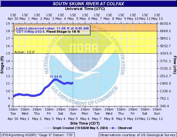
LOCATION.--Lat 41°40'53", long 93°14'47"
referenced to North American Datum of 1927, in NE 1/4 NE 1/4 SW 1/4
sec.1, T.79 N., R.21 W., Jasper County, IA, Hydrologic Unit 07080105,
on left bank 15 ft downstream from bridge on State Highway 117, at
northern edge of Colfax, 1.0 mi downstream from Sugar Creek, 2.8 mi
upstream from Indian Creek, 95.1 mi upstream from confluence with the
North Skunk River, and 189.8 mi upstream from mouth of Skunk River.
(map)
DRAINAGE AREA.--803 mi2.
SURFACE-WATER RECORDS
PERIOD OF RECORD.--Partial-record low-flow measurements, June 1974
to June 1977; discharge records from October 1985 to current
year.
REVISED RECORDS.--WDR IA-01-1: 2000.
GAGE.--Water-stage recorder. Datum of gage is 770.00 ft above
National Geodetic Vertical Datum of 1929.
WATER-QUALITY RECORDS
PERIOD OF RECORD.--Water years 1989-1993.
PERIOD OF DAILY RECORD.--
SPECIFIC CONDUCTANCE: Daily instantaneous values collected in
conjunction with suspended-sediment samples, October 1988 to December
1993, records fragmentary.
WATER TEMPERATURE: Daily instantaneous values collected in
conjunction with suspended-sediment samples, October 1988 to December
1993, records fragmentary.
SUSPENDED-SEDIMENT CONCENTRATION AND DISCHARGE: October 1988 to
December 1993.
 Site Information