USGS 06599900 Perry Creek near Millnerville, IA

PROVISIONAL DATA SUBJECT TO REVISION

Click to hidestation-specific text

> Site Information

> Images

> National Weather Service River Forecast

Funding For This Site Provided By:

Link to Upstream Gage

Iowa WSC Gage Network

Link to Downstream Gage


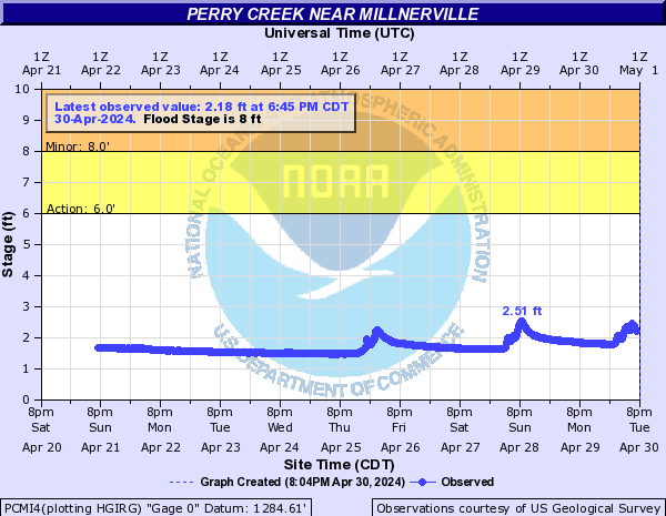
Stage values provided by this station are used to assist in verification of annual peaks and to assist in the planning of response to hydrologic events. Data is provisional and is not subject to all published USGS quality assurance policies and procedures. As such, the real-time data is served temporarily and only available for 120 days. Discretion should be applied in the use of this data for other purposes.


This station managed by the Council Bluffs Field Office.

Available Parameters Available Period
  
2012-03-23  2016-08-09
2022-10-01  2025-11-05


 (7)
 

  -- or --


Summary of all available data for this site
Instantaneous-data availability statement


Discharge, cubic feet per second

Most recent instantaneous value: 2.78 08-09-2016   13:45 CDT
Graph of  Discharge, cubic feet per second

Add up to 2 more sites and replot for "Discharge, cubic feet per second"

?


Create presentation-quality / stand-alone graph.   Subscribe to WaterAlert      

See this graph on the Monitoring Location Pages


Daily discharge, cubic feet per second -- statistics for Nov 5 based on 4 water years of record more
Most Recent
Instantaneous
Value Nov 5
Min
(2013)
25th
percen-
tile
Median Mean 75th
percen-
tile
Max
(2016)
-- unavailable -- 0.32 0.35 2.2 2.7 5.6 6.14


Gage height, feet, [Stage-only]

Most recent instantaneous value: 1.09 11-05-2025   03:45 CST
Graph of  Gage height, feet, [Stage-only]

Add up to 2 more sites and replot for "Gage height, feet, [Stage-only]"

?


Create presentation-quality / stand-alone graph.   Subscribe to WaterAlert      

See this graph on the Monitoring Location Pages