USGS 03260050 DRY CREEK AT SEWAGE PLANT NEAR ERLANGER, KY

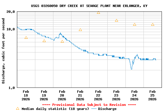
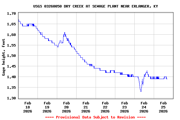
PROVISIONAL DATA SUBJECT TO REVISION

Click to hidestation-specific text


This site is operated in cooperation with the

Sanitation District No. 1 Logo

Sanitation District No. 1

Boating safety tips

Available Parameters Available Period
  
2007-10-04  2014-10-01
2007-10-01  2024-05-08
2007-10-01  2024-05-08
2007-10-04  2014-10-01
2007-10-04  2014-10-01
2007-10-04  2014-10-01
2007-10-04  2014-10-01


 (7)
 

  -- or --


Summary of all available data for this site
Instantaneous-data availability statement


Discharge, cubic feet per second

Most recent instantaneous value: 34.2 05-08-2024   22:40 EDT
Graph of  Discharge, cubic feet per second

Add up to 2 more sites and replot for "Discharge, cubic feet per second"

?


Create presentation-quality / stand-alone graph.   Subscribe to WaterAlert      

See this graph on the Monitoring Location Pages


Daily discharge, cubic feet per second -- statistics for May 8 based on 16 water years of record more
Min
(2014)
25th
percen-
tile
Median Mean 75th
percen-
tile
Most Recent
Instantaneous
Value May 8
Max
(2011)
0.98 10 17 23 31 34.2 70.7


Gage height, feet

Most recent instantaneous value: 1.74 05-08-2024   22:40 EDT
Graph of  Gage height, feet

Add up to 2 more sites and replot for "Gage height, feet"

?


Create presentation-quality / stand-alone graph.   Subscribe to WaterAlert      

See this graph on the Monitoring Location Pages