Most recent instantaneous value: *** 10-26-2024 00:45 CDT
See this graph on the Monitoring Location Pages
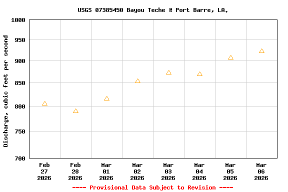
| Most Recent Instantaneous Value Mar 6 | Min (2024) | Mean | Median | Max (2023) |
|---|---|---|---|---|
| -- unavailable -- | 909 | 922 | 922 | 936 |
| Most Recent Instantaneous Value Mar 6 | Min (2024) | Mean | Median | Max (2023) |
|---|---|---|---|---|
| -- unavailable -- | 909 | 922 | 922 | 936 |
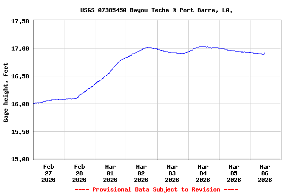
![Graph of Stream water level elevation above NAVD 1988, in feet, [NAVD88 GEOID18]](https://natwebvaww02.er.usgs.gov/nwisweb/data/img/USGS.07385450.311890.63160..20260227.20260306..0..gif)
![]() U.S. Department of the Interior |
U.S. Geological Survey
U.S. Department of the Interior |
U.S. Geological Survey
Title: USGS Current Conditions for Louisiana
URL:
Page Contact Information: Louisiana Water Data Support Team
Page Last Modified: 2026-03-06 06:00:13 EST
3.45 2.85 vaww02