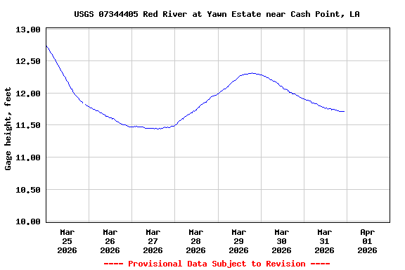
USGS 07344405 Red River at Yawn Estate near Cash Point, LA

PROVISIONAL DATA SUBJECT TO REVISION

This station managed by the Ruston Field Office.

Available Parameters Available Period
  
2023-09-25  2025-10-13
2025-06-15  2025-10-13


 (7)
 

  -- or --


Summary of all available data for this site
Instantaneous-data availability statement


Gage height, feet

Most recent instantaneous value: 10.97 10-13-2025   16:30 CDT
Graph of  Gage height, feet

Add up to 2 more sites and replot for "Gage height, feet"

?


Create presentation-quality / stand-alone graph.   Subscribe to WaterAlert      

See this graph on the Monitoring Location Pages


Stream water level elevation above NAVD 1988, in feet

Most recent instantaneous value: 145.98 10-13-2025   16:30 CDT
Graph of  Stream water level elevation above NAVD 1988, in feet

Add up to 2 more sites and replot for "Stream water level elevation above NAVD 1988, in feet"

?


Create presentation-quality / stand-alone graph.   Subscribe to WaterAlert      

See this graph on the Monitoring Location Pages