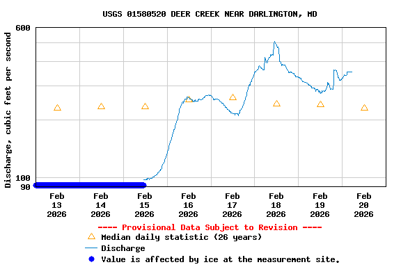
PROVISIONAL DATA SUBJECT TO REVISION
Click to hidestation-specific text
 LOCATION.--Lat 39°37'02.8", long 76°11'30.7",
Harford County, MD, Hydrologic Unit 02050306, on right bank at Deer
Creek pumping station, 1.4 miles southeast of Darlington, 0.7 mile east
of Wilson Mill, and 3.5 miles upstream from mouth.
LOCATION.--Lat 39°37'02.8", long 76°11'30.7",
Harford County, MD, Hydrologic Unit 02050306, on right bank at Deer
Creek pumping station, 1.4 miles southeast of Darlington, 0.7 mile east
of Wilson Mill, and 3.5 miles upstream from mouth.DRAINAGE AREA.-164 mi2.
PERIOD OF RECORD.--January 2000 to current year.
REVISIONS HISTORY.--https://waterdata.usgs.gov/nwis/dv/?site_no=01580520: 2000-2004.
https://waterdata.usgs.gov/nwis/uv/?site_no=01580520: 2017-2018.
GAGE.--Water-stage recorder and crest-stage gage. Datum of gage is 46.99 ft above North American Vertical Datum of 1988.
REMARKS.--U.S. Geological Survey satellite data-collection platform at station.
EXTREMES FOR PERIOD OF RECORD.--Maximum discharge, 12,600 ft3/s, April 30, 2014, gage height, 13.98 ft; minimum discharge, 6.3 ft3/s, Aug. 22-24, 2002.
COOPERATION.--Funding for the operation of this station is provided by the U.S. Environmental Protection Agency. Access to gage site provided by City of Aberdeen, MD.
| Boating safety tips |
Summary of all available data for this site
Instantaneous-data availability statement