PROVISIONAL DATA SUBJECT TO REVISION
Click to hidestation-specific text
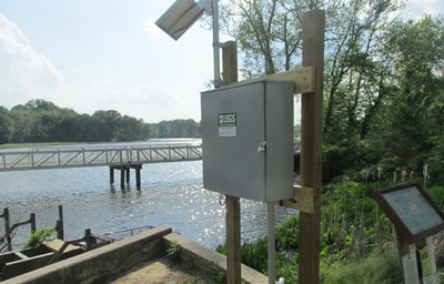
LOCATION.--Lat 39°14'39.5", long 75°35'18.2", Kent County, DE, Hydrologic Unit 02040207,
   located at northeast shore, near fish ladder and spillway, at upstream side of bridge
   on State Route 13, 1.5 mi northeast of Cheswold.
PERIOD OF RECORD.--May 2015 to current year.
GAGE.--Water-stage recorder and crest-stage gage. Datum of gage is 0.00 ft above North
   American Vertical Datum of 1988.
REMARKS.--Elevation of lake can be controlled by lift boards. U.S. Geological Survey
   satellite data-collection platform at station.
EXTREMES FOR PERIOD OF RECORD.--Maximum elevation, 7.97 ft, Oct. 12, 2018; minimum
   elevation, 5.01 ft, Sept. 7, 2015.
COOPERATION.--Funding for the operation of this station is provided by Delaware Geological
   Survey and the Delaware Department of Transportation.
Elevation of spillway is 4.78 ft. NAVD88
Summary of all available data for this site
Instantaneous-data availability statement
