PROVISIONAL DATA SUBJECT TO REVISION
Click to hidestation-specific text
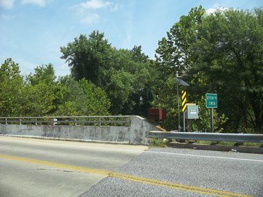
LOCATION.--Lat 39°26'21.4", long 76°18'21.7", referenced to North American Datum of 1983, Harford County, MD,
   Hydrologic Unit 02060003, on right downstream wingwall of bridge on MD-755 (Edgewood Road), 1.0 mi northwest
   of Edgewood, 2.3 mi southwest of Abingdon, 2.4 mi east of Joppa, and 3.8 mi upstream from mouth.
DRAINAGE AREA.--55.6 mi².
PERIOD OF RECORD.--January 2000 to January 2021.
REVISIONS HISTORY.--https://waterdata.usgs.gov/nwis/dv/?site_no=01581757: 2005-2014.
GAGE.--Water-stage recorder and crest-stage gage. Datum of gage is 4.71 ft above North American Vertical Datum
   of 1988.
REMARKS.--U.S. Geological Survey satellite data-collection platform at station.
EXTREMES FOR PERIOD OF RECORD.--Maximum discharge, 6,150 ft3/s, April 30, 2014, gage height, 11.86 ft;
   minimum discharge, 0.24 ft3/s, August 22, 2002.
COOPERATION.--Funding for the operation of this station is provided by the U.S. Army (Aberdeen Proving Ground),
   and the U.S. Geological Survey.
| Boating safety tips |
Summary of all available data for this site
Instantaneous-data availability statement