USGS 01591700 HAWLINGS RIVER NEAR SANDY SPRING, MD

PROVISIONAL DATA SUBJECT TO REVISION

Click to hidestation-specific text

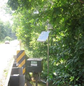
LOCATION.--Lat 39°10'28.3", long 77°01'17.1", Montgomery County, MD, Hydrologic Unit 02060006, 
   on right bank at downstream side of bridge on State Highway 650, 1.0 mi upstream from mouth, 
   and 1.7 mi north of Sandy Spring.
DRAINAGE AREA.--27.0 mi2.
PERIOD OF RECORD.--June 1978 to current year.
REVISIONS HISTORY.--WDR MD-DE-DC-03-1: 1996-98, 2000-01(P). https://waterdata.usgs.gov/nwis/dv/?site_no=01591700: 2014-2015.
GAGE.--Water-stage recorder and crest-stage gage. Datum of gage is 302.85 ft above North American
   Vertical Datum of 1988. 
REMARKS.--U.S. Geological Survey satellite data-collection platform at station.
EXTREMES FOR PERIOD OF RECORD.--Maximum discharge, 5,180 ft³/s, Jan. 19, 1996, gage height, 9.24 ft;
   minimum discharge, 0.12 ft³/s, Aug. 23, 24, 2002.
COOPERATION.--Funding for the operation of this station is provided by the Washington Suburban Sanitary
   Commission, and the U.S. Geological Survey.
Boating safety tips
This station managed by the MD-DE-DC Water Science Center Baltimore office.

Available Parameters Available Period
  
1988-05-17  2024-04-19
2007-10-01  2024-04-19


 (7)
 

  -- or --


Summary of all available data for this site
Instantaneous-data availability statement


Discharge, cubic feet per second

Most recent instantaneous value: 22.0 04-19-2024   23:45 EDT
Graph of

Add up to 2 more sites and replot for "Discharge, cubic feet per second"

?


Create presentation-quality / stand-alone graph.   Subscribe to WaterAlert      

See this graph on the Monitoring Location Pages


Daily discharge, cubic feet per second -- statistics for Apr 20 based on 45 water years of record more
Min
(2002)
Most Recent
Instantaneous
Value Apr 20
25th
percen-
tile
Median Mean 75th
percen-
tile
Max
(2015)
10.5 22.0 22 29 38 41 165


Gage height, feet

Most recent instantaneous value: 0.65 04-19-2024   23:45 EDT
Graph of

Add up to 2 more sites and replot for "Gage height, feet"

?


Create presentation-quality / stand-alone graph.   Subscribe to WaterAlert      

See this graph on the Monitoring Location Pages