USGS 02082585 TAR RIVER AT NC 97 AT ROCKY MOUNT, NC

PROVISIONAL DATA SUBJECT TO REVISION

Click to hidestation-specific text
Rocky Mount Logo 
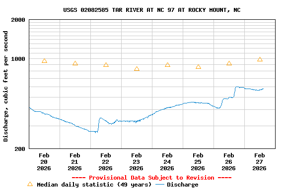
This station is operated in cooperation with the City of Rocky Mount, North Carolina.

Tar River Basin Flood-Inundation Maps are available for this site.

Forecasts for gage height (stage) are available for this station through the National Weather Service's River Forecast Center.

Boating safety tips
This station managed by the South Atlantic WSC Raleigh Field Office.

Available Parameters Available Period
  
2007-10-01  2025-09-29
1985-10-01  2025-09-29
2007-10-01  2025-09-29


 (7)
 

  -- or --


Summary of all available data for this site
Instantaneous-data availability statement


Discharge, cubic feet per second

Most recent instantaneous value: 72.8 09-29-2025   10:45 EDT
Graph of  Discharge, cubic feet per second

Add up to 2 more sites and replot for "Discharge, cubic feet per second"

?


Create presentation-quality / stand-alone graph.   Subscribe to WaterAlert      

See this graph on the Monitoring Location Pages


Daily discharge, cubic feet per second -- statistics for Sep 29 based on 48 water years of record more
Min
(2007)
Most Recent
Instantaneous
Value Sep 29
25th
percen-
tile
Median 75th
percen-
tile
Mean Max
(1999)
8.42 72.8 86 168 308 492 5320