USGS 01077400 COCKERMOUTH RIVER BELOW HARDY BROOK, AT GROTON, NH

PROVISIONAL DATA SUBJECT TO REVISION

Click to hidestation-specific text

Station operated in cooperation with the New Hampshire Department of Environmental Services.
Boating safety tips
Available Parameters Available Period
  
2008-09-13  2026-03-02
2008-09-12  2026-03-02


 (7)
 

  -- or --


Summary of all available data for this site
Instantaneous-data availability statement


Discharge, cubic feet per second

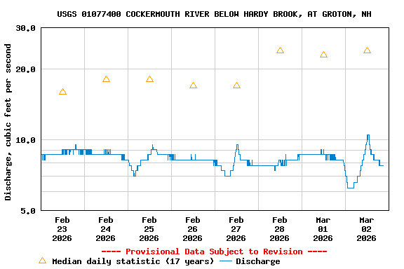
Most recent instantaneous value: 7.78 03-02-2026   20:00 EST
Graph of

Add up to 2 more sites and replot for "Discharge, cubic feet per second"

?


Create presentation-quality / stand-alone graph.   Subscribe to WaterAlert      

See this graph on the Monitoring Location Pages


Daily discharge, cubic feet per second -- statistics for Mar 2 based on 17 water years of record more
Most Recent
Instantaneous
Value Mar 2
Min
(2015)
25th
percen-
tile
Median Mean 75th
percen-
tile
Max
(2017)
7.78 9.27 10 24 45 46 236