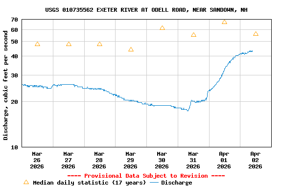
USGS 010735562 EXETER RIVER AT ODELL ROAD, NEAR SANDOWN, NH

PROVISIONAL DATA SUBJECT TO REVISION

Click to hidestation-specific text

Station operated in cooperation with the New Hampshire Department of Environmental Services.
Boating safety tips
Available Parameters Available Period
  
2008-09-27  2025-11-05
2008-09-26  2025-11-05


 (7)
 

  -- or --


Summary of all available data for this site
Instantaneous-data availability statement


Discharge, cubic feet per second

Most recent instantaneous value: 0.71 11-05-2025   16:30 EST
Graph of  Discharge, cubic feet per second

Add up to 2 more sites and replot for "Discharge, cubic feet per second"

?


Create presentation-quality / stand-alone graph.   Subscribe to WaterAlert      

See this graph on the Monitoring Location Pages


Daily discharge, cubic feet per second -- statistics for Nov 5 based on 17 water years of record more
Min
(2025)
Most Recent
Instantaneous
Value Nov 5
25th
percen-
tile
Median Mean 75th
percen-
tile
Max
(2019)
0.01 0.71 2.1 12 23 28 131


Gage height, feet

Most recent instantaneous value: 0.39 11-05-2025   16:30 EST
Graph of  Gage height, feet

Add up to 2 more sites and replot for "Gage height, feet"

?


Create presentation-quality / stand-alone graph.   Subscribe to WaterAlert      

See this graph on the Monitoring Location Pages