Funding for this site is provided by:
 STATION.
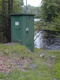
--01439500 BUSH KILL AT SHOEMAKERS, PA
LOCATION.--Lat 41`05'17", long
75`02'17", Monroe County, Hydrologic Unit 02040104, on right
bank 30 ft downstream from highway bridge, 0.1 mi downstream from Saw
Creek, 0.7 mi northwest of Shoemakers, and 2.0 mi southwest of
Bushkill.
DRAINAGE AREA.--117 square miles.
PERIOD OF RECORD.--October 1908 to current year.
Monthly discharge only for some periods, published in WSP 1302. Prior
to October 1928, published as Bushkill Creek near Shoemakers; October
1928 to September 1952, published as Bushkill Creek at
Shoemakers.
GAGE.--Water-stage recorder and crest-stage gage.
Datum of gage is 420.4 ft above North American Vertical Datum of 1988
from GNSS survey. Sept. 19, 1908, to Aug. 12, 1938, non-recording gage,
and Aug. 13, 1938, to June 20, 1956, water-stage recorder at site 50 ft
upstream at same datum. Prior to July 7, 2023, the datum of gage was
reported as 421.13 ft above National Geodetic Vertical Datum of 1929.
Satellite telemetry at station.
COOPERATION.--Station established and maintained by
the U.S. Geological Survey. Funding for the operation of this station
is provided by the Pennsylvania Department of Environmental Protection
and the U.S. Geological Survey.
GAGE HEIGHTS OF IMPORTANCE.-
Supplied by USGS: Maximum recordable gage height
(stage sensor operational limit) - 16.6 ft; Data transmitter
operational limit - 17.6 ft;
Supplied by NWS: Action stage-5 ft; Flood stage-6 ft;
Moderate flood stage-7 ft; Major flood stage-8 ft.

