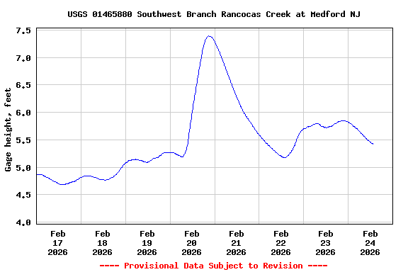
During winter months, cold and ice may
result in inaccurate real-time gage height and streamflow data.
Adjustments or deletions of this data can only be done after detailed
analysis.
Funding for this site is provided by:
SURFACE-WATER RECORDS
LOCATION.--Lat 39°53'43", long 74°49'25"
referenced to North American Datum of 1983, Medford Township,
Burlington County, NJ, Hydrologic Unit 02040202, at upstream left
wingwall of bridge on Argonne Highway (County Route 541), 0.6 mi south
of intersection of Argonne Highway and State Route 70 at Medford, and
5.3 mi upstream from the mouth.
DRAINAGE AREA.--47.2 mi².
PERIOD OF RECORD.--Occasional low-flow measurements, water years
1961-66, 1973, 1982-93, 1997, and 2002. Annual maximum gage, water
years 1983-95. Continuous-record discharge station, water years
2005-12. Continuous-record gage-height station with annual maximum
discharge, water years 2013 to current year.
GAGE.--Water-stage and precipitation recorder with telemetry and
crest-stage gage. Datum of gage is 18.38 ft above NGVD of 1929.
REMARKS.--Annual peak data can be obtained by selecting Peak
streamflow from the 'Available data for this site' drop-down
menu above or by using this
link.
EXTREMES FOR PERIOD OF RECORD.--Maximum discharge, 2,900 ft³/s,
Apr 16, 2007, gage height, 14.67 ft; minimum discharge, not
determined.
EXTREMES OUTSIDE PERIOD OF RECORD.--Maximum discharge since at
least 1940, 12,400 ft³/s, July 13, 2004, from rating curve extended
above 4,200 ft³/s on basis of contracted opening and flow-over-road
computation of peak flow, gage height, 19.7 ft, from high-water
mark.
Peak
Flood Chart

National Weather Service flood stage for
this gage is 12 ft.
Rain gage data is available from this location at this
link.