USGS 08406500 PECOS RIVER NEAR MALAGA, NM

PROVISIONAL DATA SUBJECT TO REVISION

Click to hidestation-specific text
Station operated in cooperation with the Pecos River Commission.
This station managed by the Las Cruces Field Office.

Available Parameters Available Period
  
2012-09-30  2024-11-26
1991-07-31  2026-02-24
2007-10-01  2026-02-24
2014-10-03  2024-11-26


 (7)
 

  -- or --


Summary of all available data for this site
Instantaneous-data availability statement

Temperature, water, degrees Celsius
 
-- Data temporarily unavailable for the time period specified --


Discharge, cubic feet per second

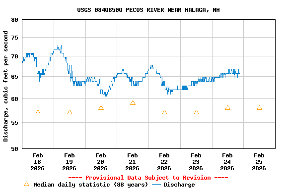
Most recent instantaneous value: 65.8 02-24-2026   21:00 MST
Graph of  Discharge, cubic feet per second

Add up to 2 more sites and replot for "Discharge, cubic feet per second"

?


Create presentation-quality / stand-alone graph.   Subscribe to WaterAlert      

See this graph on the Monitoring Location Pages


Daily discharge, cubic feet per second -- statistics for Feb 25 based on 88 water years of record more
Min
(1965)
25th
percen-
tile
Median Most Recent
Instantaneous
Value Feb 25
Mean 75th
percen-
tile
Max
(1987)
11.0 41 58 65.8 78 86 401


Gage height, feet

Most recent instantaneous value: 2.79 02-24-2026   21:00 MST
Graph of  Gage height, feet

Add up to 2 more sites and replot for "Gage height, feet"

?


Create presentation-quality / stand-alone graph.   Subscribe to WaterAlert      

See this graph on the Monitoring Location Pages


Specific conductance, water, unfiltered, microsiemens per centimeter at 25 degrees Celsius
 
-- Data temporarily unavailable for the time period specified --