USGS 10346000 TRUCKEE R A FARAD CA

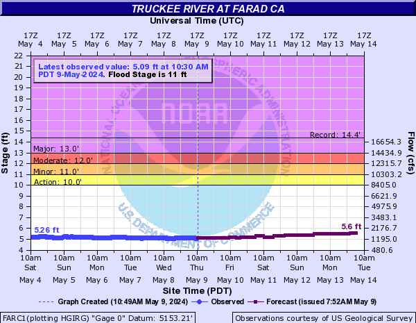
PROVISIONAL DATA SUBJECT TO REVISION

Click to hidestation-specific text
> Precipitation Data - see site 392541120015901

Click to enlarge
Site Photo
> Rating Information
This station managed by the Truckee Field Office.

Available Parameters Available Period
  
2021-05-21  2024-05-20
1987-10-01  2024-05-20
2007-10-01  2024-05-20
2007-10-01  2024-02-16
2017-10-31  2024-05-20


 (7)
 

  -- or --


Summary of all available data for this site
Instantaneous-data availability statement


Discharge, cubic feet per second

Most recent instantaneous value: 1380 05-20-2024   13:30 PDT
Graph of  Discharge, cubic feet per second

Add up to 2 more sites and replot for "Discharge, cubic feet per second"

?


Create presentation-quality / stand-alone graph.   Subscribe to WaterAlert      

See this graph on the Monitoring Location Pages


Daily discharge, cubic feet per second -- statistics for May 20 based on 115 water years of record more
Min
(1934)
25th
percen-
tile
Median Most Recent
Instantaneous
Value May 20
Mean 75th
percen-
tile
Max
(1952)
247 903 1360 1380 1740 2140 5860


Gage height, feet

Most recent instantaneous value: 5.25 05-20-2024   13:30 PDT
Graph of  Gage height, feet

Add up to 2 more sites and replot for "Gage height, feet"

?


Create presentation-quality / stand-alone graph.   Subscribe to WaterAlert      

See this graph on the Monitoring Location Pages