Funding for this site is provided by:
 STATION.
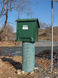
--01446775 BUSHKILL CREEK ABOVE RT 33 BRIDGE
AT TATAMY, PA
LOCATION.--Lat 40`44'56", long
75`15'56", Northampton County, Hydrologic Unit 02040105, on
right bank, 100 ft upstream of Route 33 bridge at Tatamy.
DRAINAGE AREA.--31.1 square miles.
PERIOD OF RECORD.--November 2005 to current
year.
GAGE.--Water-stage recorder and crest-stage gage.
Datum of gage is 331.775 ft above North American Vertical Datum of
1988, from GNSS Level II RTN Survey. Satellite telemetry at
station.
COOPERATION.--Station established and maintained by
the U.S. Geological Survey in cooperation with Hercules Cement Company,
Inc.
REMARKS.--Water is pumped from the Hercules quarry
0.25 miles upstream.
GAGE HEIGHTS OF IMPORTANCE.--
Supplied by USGS:Maximum recordable gage height (stage
operational limit) - 15.7 ft;

