Warning: Javascript must be enabled to use all the features on this page!


Page Loading - Please Wait...

* We've detected you're using a mobile device. Find our Next Generation Station Page here.
Click to hideNews Bulletins

USGS 01585230 MOORES RUN AT RADECKE AVE AT BALTIMORE, MD

PROVISIONAL DATA SUBJECT TO REVISION

Click to hidestation-specific text
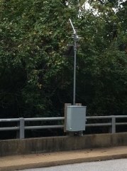
LOCATION.--Lat 39°19'48.3", long 76°32'05.6", Baltimore City, MD, Hydrologic Unit 02060003, on right
   downstream side of bridge on Radecke Avenue, at Baltimore, and 2.0 mi upstream from mouth.
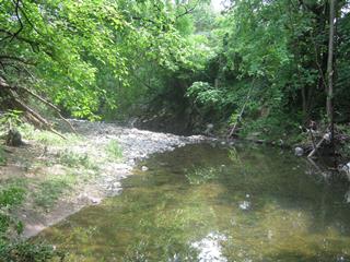
DRAINAGE AREA.--3.52 mi2.
PERIOD OF RECORD.--July 1996 to October 2022.
REVISIONS HISTORY--WDR-US-2006: 1996-2005(P).
GAGE.--Water-stage recorder and crest-stage gage. Datum of gage is 39.41 ft above North American
   Vertical Datum of 1988.
REMARKS.--U.S. Geological Survey satellite data-collection platform at station. Water-quality
   records for some prior periods have been collected at this location.
EXTREMES FOR PERIOD OF RECORD.--Maximum discharge, 4,380 ft3/s, June 13, 2003,
   gage height, 10.48 ft; minimum discharge, 0.10 ft3/s, June 30, July 1-5, 2010.
Boating safety tips
This station managed by the MD-DE-DC Water Science Center Baltimore office.

Available Parameters Period of Record
  
2015-10-02  2022-10-10
1996-07-23  2022-10-10
2015-10-02  2022-10-10


 (365)
 

  -- or --


Summary of all available data for this site
Instantaneous-data availability statement
*** There are no data available on the Waterdata system for the time period specified,
    although data may be available in the files of the local USGS office operating the station.