Warning: Javascript must be enabled to use all the features on this page!


Page Loading - Please Wait...

Click to hideNews Bulletins
  • Explore the NEW USGS National Water Dashboard interactive map to access real-time water data from over 13,500 stations nationwide.
  • How are we doing? We want to hear from you. Take our quick survey to tell us what you think.

USGS 05451770 Iowa River at County Highway E49 near Tama, IA

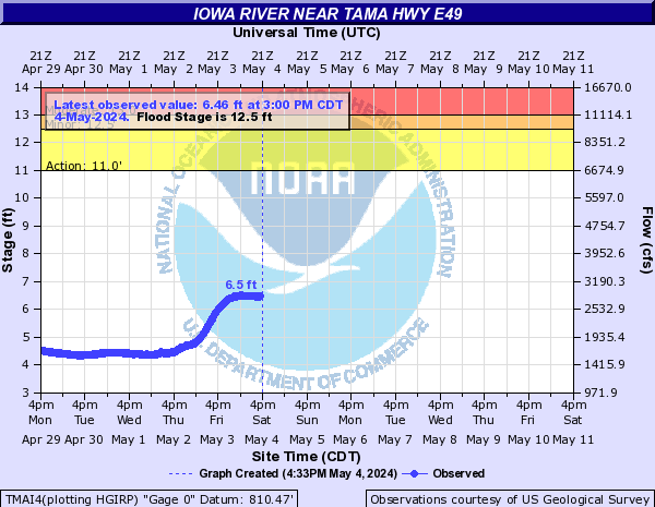
PROVISIONAL DATA SUBJECT TO REVISION

Click to hidestation-specific text

> Site Information

> Images

> National Weather Service River Forecast

Funding For This Site Provided By:

Link to Upstream Gage

Iowa WSC Gage Network

Link to Downstream Gage


This station managed by the Iowa City Field Office.

Available Parameters Period of Record
  
2011-06-08  2024-10-05


 (365)
 

  -- or --


Summary of all available data for this site
Instantaneous-data availability statement


Discharge, cubic feet per second


Graph of DAILY Discharge, cubic feet per second

Add up to 2 more sites and replot for "Discharge, cubic feet per second"

?


Create presentation-quality graph.