USGS 09353800 LOS PINOS RIVER NEAR IGNACIO, CO

PROVISIONAL DATA SUBJECT TO REVISION

This station managed by the Durango Field Office.

Available Parameters Available Period
  
1999-10-01  2026-03-01
2020-10-09  2026-03-01


 (7)
 

  -- or --


Summary of all available data for this site
Instantaneous-data availability statement


Discharge, cubic feet per second

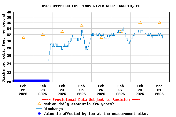
Most recent instantaneous value: 30.0 03-01-2026   17:45 MST
Graph of

Add up to 2 more sites and replot for "Discharge, cubic feet per second"

?


Create presentation-quality / stand-alone graph.   Subscribe to WaterAlert      

See this graph on the Monitoring Location Pages


Daily discharge, cubic feet per second -- statistics for Mar 1 based on 26 water years of record more
Min
(2021)
25th
percen-
tile
Most Recent
Instantaneous
Value Mar 1
Median Mean 75th
percen-
tile
Max
(2005)
4.83 13 30.0 36 104 111 663