USGS 411940071590300 MYSTIC RIVER AT RAM ISLAND YACHT CLUB AT NOANK, CT

PROVISIONAL DATA SUBJECT TO REVISION

This station managed by the East Hartford CT Field Office.

Available Parameters Available Period
  
2021-05-11  2023-04-10
2021-05-11  2024-10-01
2021-05-11  2023-04-10
2021-05-11  2024-10-01
2021-05-11  2023-04-10
2021-05-11  2024-10-01
2021-05-11  2023-04-10
2021-05-11  2024-10-01
2023-04-10  2024-10-01
2021-05-11  2024-10-01
2021-10-21  2023-04-10
2021-05-11  2024-10-01
2021-05-11  2023-04-10
2021-10-05  2023-04-10
2021-10-05  2023-04-10
2021-10-05  2023-04-10
2021-05-11  2023-04-10
2021-05-11  2024-10-01


 (7)
 

  -- or --


Summary of all available data for this site
Instantaneous-data availability statement


Turbidity, water, unfiltered, monochrome near infra-red LED light, 780-900 nm, detection angle 90 +-2.5 degrees, formazin nephelometric units (FNU), BOTTOM

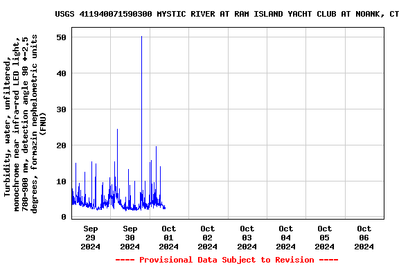
Most recent instantaneous value: 2.5 10-01-2024   09:24 EDT
Graph of

Add up to 2 more sites and replot for "Turbidity, water, unfiltered, monochrome near infra-red LED light, 780-900 nm, detection angle 90 +-2.5 degrees, formazin nephelometric units (FNU), BOTTOM"

?


Create presentation-quality / stand-alone graph.   Subscribe to WaterAlert      

See this graph on the Monitoring Location Pages


Turbidity, water, unfiltered, monochrome near infra-red LED light, 780-900 nm, detection angle 90 +-2.5 degrees, formazin nephelometric units (FNU), TOP
 
-- Data temporarily unavailable for the time period specified --