USGS 02264060 LATERAL 101 AT S-101, NEAR LAKE BUENA VISTA, FL

PROVISIONAL DATA SUBJECT TO REVISION

Click to hidestation-specific text

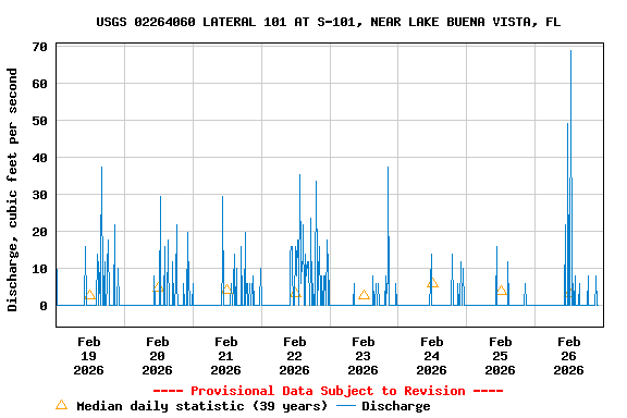
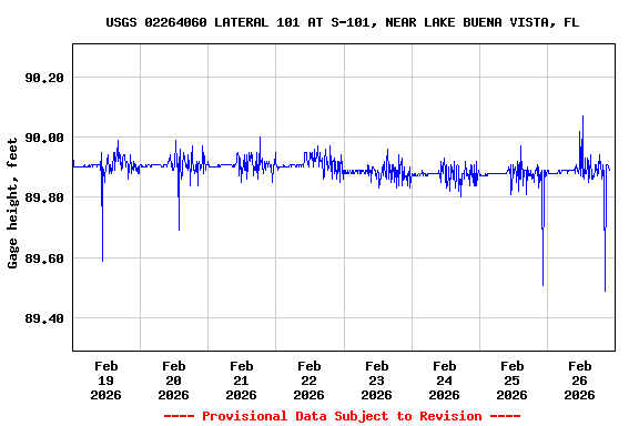
This gage is monitored in cooperation with the Reedy Creek Improvement District.

Reedy Creek Improvement District

REMARKS.--Flow regulated by operation of structure 101. Discharge computed from relation between discharge and gate openings and does not include leakage around structure or gates, which is less than 5.0 ft3/s.

Available Parameters Available Period
  
2000-10-02  2024-03-29
2007-10-01  2024-03-29


 (7)
 

  -- or --


Summary of all available data for this site
Instantaneous-data availability statement


Discharge, cubic feet per second

Most recent instantaneous value: 0.00 03-29-2024   03:00 EDT
Graph of

Add up to 2 more sites and replot for "Discharge, cubic feet per second"

?


Create presentation-quality / stand-alone graph.   Subscribe to WaterAlert      

See this graph on the Monitoring Location Pages


Daily discharge, cubic feet per second -- statistics for Mar 29 based on 37 water years of record more
Most Recent
Instantaneous
Value Mar 29
Min
(1995)
25th
percen-
tile
Median Mean 75th
percen-
tile
Max
(1987)
0.00 0.00 0 5.7 17 23 175


Gage height, feet

Most recent instantaneous value: 89.83 03-29-2024   03:00 EDT
Graph of

Add up to 2 more sites and replot for "Gage height, feet"

?


Create presentation-quality / stand-alone graph.   Subscribe to WaterAlert      

See this graph on the Monitoring Location Pages