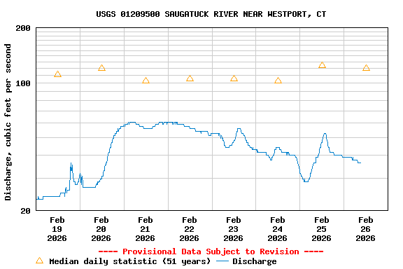
USGS 01209500 SAUGATUCK RIVER NEAR WESTPORT, CT

PROVISIONAL DATA SUBJECT TO REVISION

Click to hidestation-specific text
Available Parameters Available Period
  
2009-07-02  2025-11-19
2015-01-21  2025-11-19


 (7)
 

  -- or --


Summary of all available data for this site
Instantaneous-data availability statement


Discharge, cubic feet per second

Most recent instantaneous value: 14.5 11-19-2025   08:00 EST
Graph of  Discharge, cubic feet per second

Add up to 2 more sites and replot for "Discharge, cubic feet per second"

?


Create presentation-quality / stand-alone graph.   Subscribe to WaterAlert      

See this graph on the Monitoring Location Pages


Daily discharge, cubic feet per second -- statistics for Nov 19 based on 51 water years of record more
Min
(1966)
Most Recent
Instantaneous
Value Nov 19
25th
percen-
tile
Median Mean 75th
percen-
tile
Max
(1956)
0.60 14.5 26 42 71 72 380


Gage height, feet, [(2)]

Most recent instantaneous value: 3.10 11-19-2025   08:00 EST
Graph of  Gage height, feet, [(2)]

Add up to 2 more sites and replot for "Gage height, feet, [(2)]"

?


Create presentation-quality / stand-alone graph.   Subscribe to WaterAlert      

See this graph on the Monitoring Location Pages