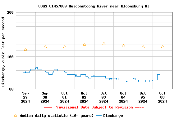
Funding for this site is provided by:
SURFACE-WATER RECORDS
LOCATION.--Lat 40°40'20", long 75°03'39"
referenced to North American Datum of 1983, Pohatcong Township, Warren
County, NJ, Hydrologic Unit 02040105, on right bank 15 ft downstream
from bridge on Limekiln Road (Person Road), 1.5 mi upstream of
Bloomsbury, and 9.5 mi upstream from mouth.
DRAINAGE AREA.--141 mi
2.
PERIOD OF RECORD.--Continuous-record discharge station July 1903
to March 1907, July 1921 to current year.
REVISED RECORDS.--WSP 1051: 1944-45. WSP 1382: 1904-06, 1922,
1923-29(M), 1931(M), 1933-34(M), 1936(M), 1940, 1942(M), 1944-45(M),
1951-52(M). WDR NJ-82-2: Drainage area.
GAGE.--Water-stage recorder with telemetry and crest-stage gage.
Concrete control since Sep 29, 1932. Datum of gage is 274.83 ft above
NGVD of 1929. Jul 1903 to Mar 31, 1907, non-recording gage at bridge 15
ft upstream at different datum. Jul 26 to Sep 12, 1921, non-recording
gage at bridge at present datum.
REMARKS.--Records good, except for estimated discharges, which
are fair. Flow occasionally regulated by unknown source and by
operation of gates at Lake Hopatcong (see 01455400 and 01455500).
EXTREMES FOR PERIOD OF RECORD.--Maximum discharge, 7,200
ft
3/s, from rating curve extended above 4,500
ft
3/s on basis of slope-area computation of peak flow, Jan
25, 1979, gage height, 8.50 ft; maximum gage height, 8.75 ft, Aug 28,
2011; minimum discharge, 8.1 ft
3/s, Aug 2, 1955.
Peak
Flood Chart

National Weather Service flood stage for
this gage is 6 ft.