PROVISIONAL DATA SUBJECT TO REVISION
Click to hidestation-specific text
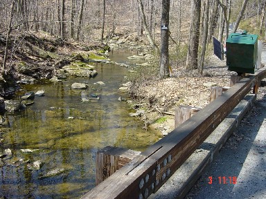
LOCATION.--Lat 39°29'46.6", long 76°20'50.8", Harford County, MD, Hydrologic Unit 02060003, on downstream
   side of bridge on Plumtree Road, 2.5 mi south of Bel Air.
DRAINAGE AREA.--2.50 mi2.
PERIOD OF RECORD.--October 2001 to current year.
REVISIONS HISTORY.--
- WDR-US-2006: 2003-04 (P).
- https://waterdata.usgs.gov/nwis/dv/?site_no=01581752: 2002-2017 (Discharge)
- https://nwis.waterdata.usgs.gov/md/nwis/peak?site_no=01581752: 2009 (Peak)
- https://waterdata.usgs.gov/nwis/uv/?site_no=01581752: 2021 (Specific Conductance)
- https://waterdata.usgs.gov/nwis/uv/?site_no=01581752: 2021 (Turbidity)
- The indirect discharge for Measurement 146S was revised on 09/21/2022 due to sensor malfunction that was identified after the measurement had been approved.
GAGE.--Water-stage recorder and crest-stage gage. Datum of gage is 182.27 ft above North American Vertical
   Datum of 1988.
REMARKS.--U.S. Geological Survey satellite data-collection platform at station.
EXTREMES FOR PERIOD OF RECORD.--Maximum discharge, 2,380 ft3/s, June 3, 2021, gage height, 6.73 ft;
   minimum discharge 0.07 ft3/s, Aug. 19-23, 2002.
COOPERATION.--Funding for the operation of this station is provided by the Harford County Department of
   Public Works, and the U.S. Geological Survey.
| Boating safety tips |
Summary of all available data for this site
Instantaneous-data availability statement


