PROVISIONAL DATA SUBJECT TO REVISION
Click to hidestation-specific text
 |
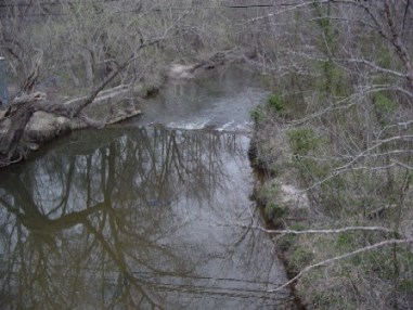 |
LOCATION.--Lat 38°42'20.8", long 76°57'58.3", Prince Georges County, MD, Hydrologic Unit 02070010,
   at downstream side of bridge on State Highway 223, at Piscataway, 0.4 mi upstream from
   Tinker Creek, and 4.8 mi upstream from mouth.
DRAINAGE AREA.--39.5 mi2.
PERIOD OF RECORD.--October 1965 to September 2005, October 2006 to current year.
REVISIONS HISTORY.--https://waterdata.usgs.gov/nwis/dv/?site_no=01653600: 2007-2014
GAGE.--Water-stage recorder, crest-stage gage, and concrete control. Datum of gage is 7.63 ft above
    North American Vertical Datum of 1988. Prior to April 28, 2016 gage located on left bank, 75 ft
   downstream at same gage datum.
REMARKS.--U.S. Geological Survey satellite data-collection platform at station.
EXTREMES FOR PERIOD OF RECORD.--Maximum discharge, 12,400 ft3/s (estimated), July 7, 2020, gage height, 15.42 ft;
   minimum discharge, 0.0 ft3/s, no flow at times in 1966, 1970, 1977, 1980-83, 1985-89, 1991-95, 1997-99,
   2002, 2005, 2007, 2008, 2010, 2012, 2013, 2015, 2019, and 2020.
COOPERATION.--Funding for the operation of this station is provided by the Maryland Department of
   Transportation, and the U.S. Geological Survey.
| Boating safety tips |
Summary of all available data for this site
Instantaneous-data availability statement

