PROVISIONAL DATA SUBJECT TO REVISION
Click to hidestation-specific text
|
This gage is monitored in cooperation with the Southwest Florida Water Management District .
|
Instantaneous-data availability statement
|
This gage is monitored in cooperation with the Southwest Florida Water Management District .
|
Temperature, water, degrees Celsius, BOTTOM |
||
|
||
Temperature, water, degrees Celsius, TOP |
||
|
||
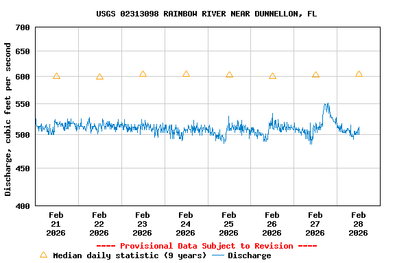
| Most Recent Instantaneous Value Feb 28 | Min (2023) | 25th percen- tile | Median | Mean | 75th percen- tile | Max (2019) |
|---|---|---|---|---|---|---|
| 500 | 539 | 561 | 604 | 624 | 669 | 808 |
Nitrate plus nitrite, water, in situ, milligrams per liter as nitrogen |
||
|
||
![]() U.S. Department of the Interior |
U.S. Geological Survey
U.S. Department of the Interior |
U.S. Geological Survey
Title: USGS Current Conditions for the Nation
URL:
Page Contact Information: Florida Water Science Center - Tampa Water Data Support Team
Page Last Modified: 2026-02-28 11:42:05 EST
7.24 5.95 vaww02