PROVISIONAL DATA SUBJECT TO REVISION
Click to hidestation-specific text
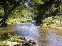 STATION.--03011800 KINZUA CREEK NEAR GUFFEY,
PA
STATION.--03011800 KINZUA CREEK NEAR GUFFEY,
PALOCATION.--Lat 41`45'59", long 78`43'08", McKean County, Hydrologic Unit 05010001, in Allegheny National Forest, on right bank 130 ft upstream from bridge on U.S. Highway 219, 0.2 mi upstream from Wintergreen Run, 1.0 mi downstream from Pine Run, and 1.5 mi west of Guffey.
DRAINAGE AREA.--38.8 square miles.
PERIOD OF RECORD.--Occasional low-flow measurements, published as "at Tallyho," water years 1959-65. October 1965 to current year.
GAGE.--Water-stage recorder and crest-stage gage. Elevation of gage is 1,540 ft above National Geodetic Vertical Datum of 1929, from topographic map. Satellite telemetry at station.
COOPERATION.--Station established and maintained by the U.S. Geological Survey. Funding for the operation of this station is provided by the U.S. Army Corps of Engineers, Pittsburgh District, the Pennsylvania Department of Environmental Protection, and the U.S. Geological Survey.
Summary of all available data for this site
Instantaneous-data availability statement

