USGS 03250190 SLATE CREEK AT HIGHWAY 713 NR MT. STERLING, KY

PROVISIONAL DATA SUBJECT TO REVISION

Click to hidestation-specific text


This site is operated in cooperation with the

City of Mount Sterling, Kentucky

Boating safety tips

This station managed by the Louisville District Office.

Available Parameters Available Period
  
2000-03-03  2026-02-21
2007-10-01  2026-02-21


 (7)
 

  -- or --


Summary of all available data for this site
Instantaneous-data availability statement


Discharge, cubic feet per second

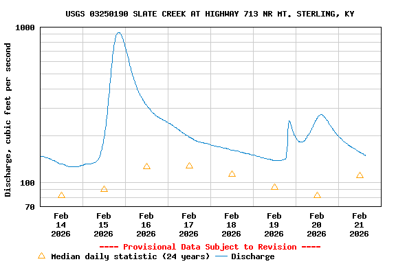
Most recent instantaneous value: 179 02-21-2026   04:15 EST
Graph of  Discharge, cubic feet per second

Add up to 2 more sites and replot for "Discharge, cubic feet per second"

?


Create presentation-quality / stand-alone graph.   Subscribe to WaterAlert      

See this graph on the Monitoring Location Pages


Daily discharge, cubic feet per second -- statistics for Feb 21 based on 24 water years of record more
Min
(2011)
25th
percen-
tile
Median Most Recent
Instantaneous
Value Feb 21
75th
percen-
tile
Mean Max
(2014)
26.6 55 111 179 198 239 1620


Gage height, feet

Most recent instantaneous value: 3.51 02-21-2026   04:15 EST
Graph of  Gage height, feet

Add up to 2 more sites and replot for "Gage height, feet"

?


Create presentation-quality / stand-alone graph.   Subscribe to WaterAlert      

See this graph on the Monitoring Location Pages