PROVISIONAL DATA SUBJECT TO REVISION
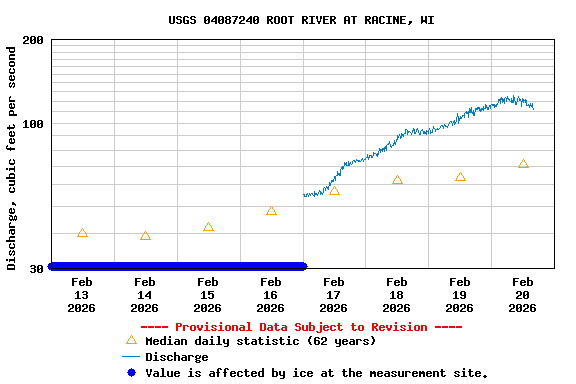
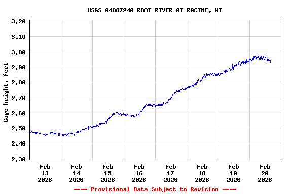
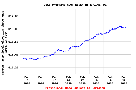
LOCATION.--Lat 42°45'05", long 87°49'25", in NW1/4 NE 1/4 sec.6, T.3 N., R.23 E., Racine County, Hydrologic Unit 04040002, on left bank 30 ft downstream from State Highway 38 bridge in Racine, 350 ft downstream from Horlick Dam, and 5.2 mi upstream from mouth.
DRAINAGE AREA.--190 square miles, of which 1.24 square miles is probably noncontributing.
PERIOD OF RECORD.--August 1963 to present.
REVISED RECORD.--WDR WI-80-1: Drainage area.
GAGE.--Water-stage recorder. Datum of gage is 613.87 ft (NAVD88), from WDOT benchmark. Prior to Feb. 5, 1964, nonrecording gage on bridge 30 ft upstream.
REMARKS.--Gage-height telemeter at station.
OPERATED IN COOPERATION WITH:


Additional Information:
 National Weather Service Flood Forecast Page
| Boating safety tips |

|
Time-lapse video products are considered a proof of concept with no guarantee regarding product up time. Time-lapse videos can be viewed using Chrome, Firefox or Opera browser application on smartphone, tablet, desktop and laptop devices. Additional browser support for Safari and Internet Explorer may be added later.
Any use of trade, firm, or product names is for descriptive purposes only and does not imply endorsement by the U.S. Government.
Summary of all available data for this site
Instantaneous-data availability statement