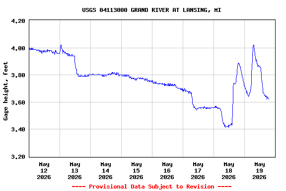
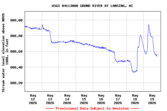
USGS 04113000 GRAND RIVER AT LANSING, MI

PROVISIONAL DATA SUBJECT TO REVISION

Click to hidestation-specific text

Station operated in cooperation with the Michigan Department of Transportation.
This station managed by the LANSING FIELD OFFICE.

Available Parameters Available Period
  
1989-10-01  2025-09-01
2017-10-01  2025-09-01
2022-08-31  2025-09-01


 (7)
 

  -- or --


Summary of all available data for this site
Instantaneous-data availability statement


Discharge, cubic feet per second

Most recent instantaneous value: 117 09-01-2025   13:00 EST
Graph of

Add up to 2 more sites and replot for "Discharge, cubic feet per second"

?


Create presentation-quality / stand-alone graph.   Subscribe to WaterAlert      

See this graph on the Monitoring Location Pages


Daily discharge, cubic feet per second -- statistics for Sep 1 based on 96 water years of record more
Min
(1946)
Most Recent
Instantaneous
Value Sep 1
25th
percen-
tile
Median Mean 75th
percen-
tile
Max
(1975)
55.0 117 186 273 376 465 2420


Gage height, feet

Most recent instantaneous value: 2.10 09-01-2025   13:00 EST
Graph of

Add up to 2 more sites and replot for "Gage height, feet"

?


Create presentation-quality / stand-alone graph.   Subscribe to WaterAlert      

See this graph on the Monitoring Location Pages


Stream water level elevation above NAVD 1988, in feet

Most recent instantaneous value: 807.02 09-01-2025   13:00 EST
Graph of

Add up to 2 more sites and replot for "Stream water level elevation above NAVD 1988, in feet"

?


Create presentation-quality / stand-alone graph.   Subscribe to WaterAlert      

See this graph on the Monitoring Location Pages