USGS 05056340 LITTLE COULEE NR LEEDS, ND

PROVISIONAL DATA SUBJECT TO REVISION

Click to hidestation-specific text
  This station is operated in cooperation with the
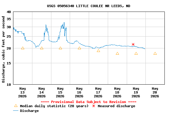
North Dakota State Water Commission logo


This station managed by the Grand Forks Field Office.

Available Parameters Available Period
  
2000-06-10  2025-11-20
2008-04-09  2025-11-20
2025-10-01  2025-11-20


 (7)
 

  -- or --


Summary of all available data for this site
Instantaneous-data availability statement


Discharge, cubic feet per second

Most recent instantaneous value: 0.60 11-20-2025   07:15 CST
Graph of  Discharge, cubic feet per second

Add up to 2 more sites and replot for "Discharge, cubic feet per second"

?


Create presentation-quality / stand-alone graph.   Subscribe to WaterAlert      

See this graph on the Monitoring Location Pages


Gage height, feet

Most recent instantaneous value: 62.50 11-20-2025   07:15 CST
Graph of  Gage height, feet

Add up to 2 more sites and replot for "Gage height, feet"

?


Create presentation-quality / stand-alone graph.   Subscribe to WaterAlert      

See this graph on the Monitoring Location Pages


Stream water level elevation above NAVD 1988, in feet

Most recent instantaneous value: 1488.51 11-20-2025   07:15 CST
Graph of  Stream water level elevation above NAVD 1988, in feet

Add up to 2 more sites and replot for "Stream water level elevation above NAVD 1988, in feet"

?


Create presentation-quality / stand-alone graph.   Subscribe to WaterAlert      

See this graph on the Monitoring Location Pages