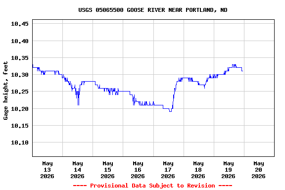
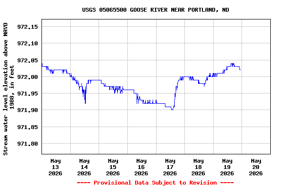
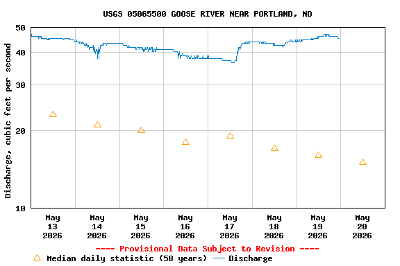
USGS 05065500 GOOSE RIVER NEAR PORTLAND, ND

PROVISIONAL DATA SUBJECT TO REVISION

Click to hidestation-specific text
This station managed by the Grand Forks Field Office.

Available Parameters Available Period
  
1985-03-20  2026-01-10
2010-03-12  2026-01-10
2025-09-12  2026-01-10


 (7)
 

  -- or --


Summary of all available data for this site
Instantaneous-data availability statement


Discharge, cubic feet per second

Most recent instantaneous value: Ssn 01-10-2026   13:45 CST
Graph of  Discharge, cubic feet per second

Add up to 2 more sites and replot for "Discharge, cubic feet per second"

?


Create presentation-quality / stand-alone graph.   Subscribe to WaterAlert      

See this graph on the Monitoring Location Pages


Daily discharge, cubic feet per second -- statistics for Jan 10 based on 38 water years of record more
Most Recent
Instantaneous
Value Jan 10
Min
(1940)
25th
percen-
tile
Median 75th
percen-
tile
Mean Max
(1970)
-- unavailable -- 0.00 0 0 0.12 0.18 1.80

Gage height, feet
 
-- Data temporarily unavailable for the time period specified --

Stream water level elevation above NAVD 1988, in feet
 
-- Data temporarily unavailable for the time period specified --