PROVISIONAL DATA SUBJECT TO REVISION
Click to hidestation-specific text
|
This station is operated in
cooperation with the |
Summary of all available data for this site
Instantaneous-data availability statement
|
This station is operated in
cooperation with the |
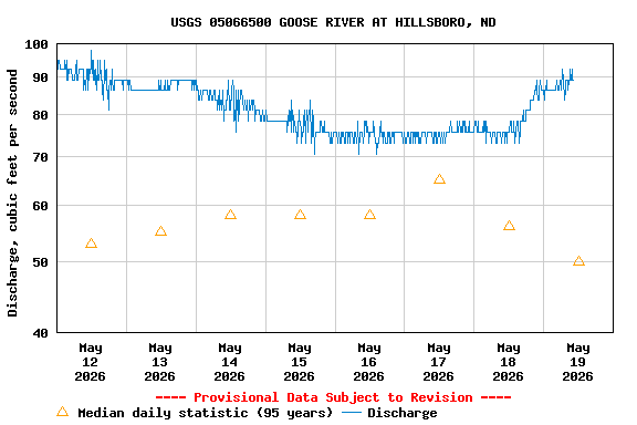
| Min (1931) | 25th percen- tile | Median | Most Recent Instantaneous Value May 19 | Mean | 75th percen- tile | Max (2022) |
|---|---|---|---|---|---|---|
| 0.70 | 15 | 50 | 89.2 | 174 | 208 | 2010 |
![]() U.S. Department of the Interior |
U.S. Geological Survey
U.S. Department of the Interior |
U.S. Geological Survey
Title: USGS Current Conditions for the Nation
URL:
Page Contact Information: North Dakota Water Data Support Team
Page Last Modified: 2026-05-19 12:00:27 EDT
1.65 1.24 caww01