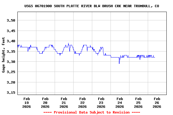
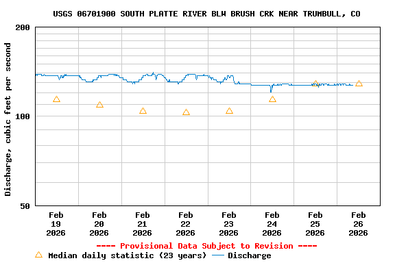
USGS 06701900 SOUTH PLATTE RIVER BLW BRUSH CRK NEAR TRUMBULL, CO

PROVISIONAL DATA SUBJECT TO REVISION

This station managed by the Lakewood Field Office.

Available Parameters Available Period
  
2002-07-19  2026-01-10
2020-03-31  2026-01-10


 (7)
 

  -- or --


Summary of all available data for this site
Instantaneous-data availability statement


Discharge, cubic feet per second

Most recent instantaneous value: 84.5 01-10-2026   17:45 MST
Graph of

Add up to 2 more sites and replot for "Discharge, cubic feet per second"

?


Create presentation-quality / stand-alone graph.   Subscribe to WaterAlert      

See this graph on the Monitoring Location Pages


Daily discharge, cubic feet per second -- statistics for Jan 10 based on 23 water years of record more
Min
(2004)
Most Recent
Instantaneous
Value Jan 10
25th
percen-
tile
Mean Median 75th
percen-
tile
Max
(2010)
47.6 84.5 85 131 142 161 212


Gage height, feet

Most recent instantaneous value: 3.07 01-10-2026   17:45 MST
Graph of

Add up to 2 more sites and replot for "Gage height, feet"

?


Create presentation-quality / stand-alone graph.   Subscribe to WaterAlert      

See this graph on the Monitoring Location Pages