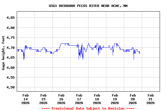
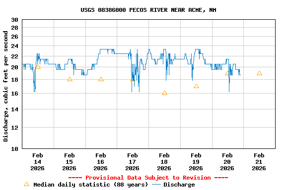
USGS 08386000 PECOS RIVER NEAR ACME, NM

PROVISIONAL DATA SUBJECT TO REVISION

Click to hidestation-specific text
Station operated in cooperation with the Pecos River Commission.
This station managed by the Las Cruces Field Office.

Available Parameters Available Period
  
1991-09-11  2025-12-10
2009-04-29  2025-12-10


 (7)
 

  -- or --


Summary of all available data for this site
Instantaneous-data availability statement


Discharge, cubic feet per second

Most recent instantaneous value: 26.4 12-10-2025   22:45 MST
Graph of  Discharge, cubic feet per second

Add up to 2 more sites and replot for "Discharge, cubic feet per second"

?


Create presentation-quality / stand-alone graph.   Subscribe to WaterAlert      

See this graph on the Monitoring Location Pages


Daily discharge, cubic feet per second -- statistics for Dec 11 based on 88 water years of record more
Min
(1948)
25th
percen-
tile
Median Most Recent
Instantaneous
Value Dec 11
Mean 75th
percen-
tile
Max
(1942)
0.00 9.3 21 26.4 31 33 338


Gage height, feet

Most recent instantaneous value: 4.72 12-10-2025   22:45 MST
Graph of  Gage height, feet

Add up to 2 more sites and replot for "Gage height, feet"

?


Create presentation-quality / stand-alone graph.   Subscribe to WaterAlert      

See this graph on the Monitoring Location Pages