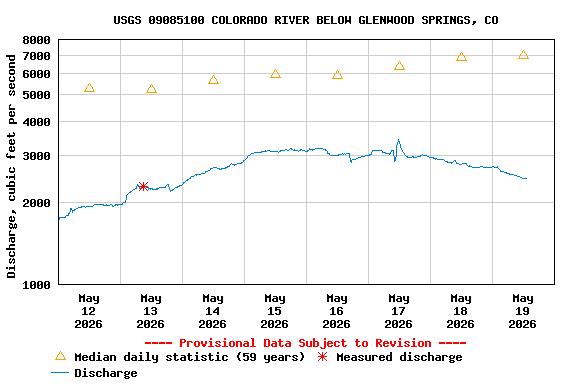
USGS 09085100 COLORADO RIVER BELOW GLENWOOD SPRINGS, CO

PROVISIONAL DATA SUBJECT TO REVISION

This station managed by the Grand Junction Field Office.

Available Parameters Available Period
  
1986-06-21  2025-08-31
2020-10-01  2025-08-31
2025-01-03  2025-08-31


 (7)
 

  -- or --


Summary of all available data for this site
Instantaneous-data availability statement


Discharge, cubic feet per second

Most recent instantaneous value: 1820 08-31-2025   22:15 MDT
Graph of  Discharge, cubic feet per second

Add up to 2 more sites and replot for "Discharge, cubic feet per second"

?


Create presentation-quality / stand-alone graph.   Subscribe to WaterAlert      

See this graph on the Monitoring Location Pages


Daily discharge, cubic feet per second -- statistics for Sep 1 based on 58 water years of record more
Most Recent
Instantaneous
Value Sep 1
Min
(2002)
25th
percen-
tile
Median Mean 75th
percen-
tile
Max
(1984)
-- unavailable -- 1320 2040 2290 2410 2610 5410


Gage height, feet

Most recent instantaneous value: 4.10 08-31-2025   22:15 MDT
Graph of  Gage height, feet

Add up to 2 more sites and replot for "Gage height, feet"

?


Create presentation-quality / stand-alone graph.   Subscribe to WaterAlert      

See this graph on the Monitoring Location Pages


Stream water level elevation above NAVD 1988, in feet

Most recent instantaneous value: 5709.52 08-31-2025   22:15 MDT
Graph of  Stream water level elevation above NAVD 1988, in feet

Add up to 2 more sites and replot for "Stream water level elevation above NAVD 1988, in feet"

?


Create presentation-quality / stand-alone graph.   Subscribe to WaterAlert      

See this graph on the Monitoring Location Pages