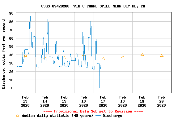
USGS 09429200 PVID C CANAL SPILL NEAR BLYTHE, CA

PROVISIONAL DATA SUBJECT TO REVISION

Click to hidestation-specific text
Station operated in cooperation with The Hualapai Tribe.

High Data Rate

This station managed by the Yuma Field Office; USGS AZ-WSC.

Available Parameters Available Period
  
2007-10-01  2026-01-11
2007-10-01  2026-01-11


 (7)
 

  -- or --


Summary of all available data for this site
Instantaneous-data availability statement


Discharge, cubic feet per second

Most recent instantaneous value: 45.8 01-11-2026   04:45 MST
Graph of  Discharge, cubic feet per second

Add up to 2 more sites and replot for "Discharge, cubic feet per second"

?


Create presentation-quality / stand-alone graph.   Subscribe to WaterAlert      

See this graph on the Monitoring Location Pages


Daily discharge, cubic feet per second -- statistics for Jan 11 based on 45 water years of record more
Min
(1980)
25th
percen-
tile
Median 75th
percen-
tile
Mean Most Recent
Instantaneous
Value Jan 11
Max
(1997)
0.00 0 0 3.4 7.7 45.8 54.8


Gage height, feet

Most recent instantaneous value: 11.17 01-11-2026   04:45 MST
Graph of  Gage height, feet

Add up to 2 more sites and replot for "Gage height, feet"

?


Create presentation-quality / stand-alone graph.   Subscribe to WaterAlert      

See this graph on the Monitoring Location Pages