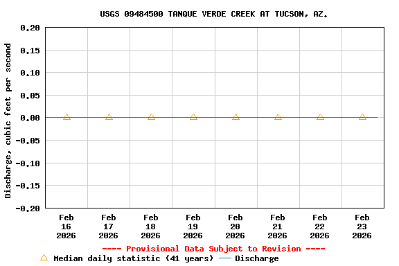
USGS 09484500 TANQUE VERDE CREEK AT TUCSON, AZ.

PROVISIONAL DATA SUBJECT TO REVISION

Click to hidestation-specific text
Station operated in cooperation with Pima County Flood Control District and the USGS.

High Data Rate

This station managed by the Tucson Field Office; USGS AZ-WSC.

Available Parameters Available Period
  
1987-07-24  2025-11-20
2022-04-04  2025-11-20


 (7)
 

  -- or --


Summary of all available data for this site
Instantaneous-data availability statement


Discharge, cubic feet per second

Most recent instantaneous value: 0.00 11-20-2025   00:00 MST
Graph of  Discharge, cubic feet per second

Add up to 2 more sites and replot for "Discharge, cubic feet per second"

?


Create presentation-quality / stand-alone graph.   Subscribe to WaterAlert      

See this graph on the Monitoring Location Pages


Daily discharge, cubic feet per second -- statistics for Nov 20 based on 44 water years of record more
Most Recent
Instantaneous
Value Nov 20
Min
(1943)
25th
percen-
tile
Median 75th
percen-
tile
Mean Max
(2001)
0.00 0.00 0 0 0 0.85 24.0


Gage height, feet, [Primary]

Most recent instantaneous value: 4.95 11-20-2025   00:00 MST
Graph of  Gage height, feet, [Primary]

Add up to 2 more sites and replot for "Gage height, feet, [Primary]"

?


Create presentation-quality / stand-alone graph.   Subscribe to WaterAlert      

See this graph on the Monitoring Location Pages