PROVISIONAL DATA SUBJECT TO REVISION
Click to hidestation-specific text
|
||||||||||||||||||||
Summary of all available data for this site
Instantaneous-data availability statement
|
||||||||||||||||||||
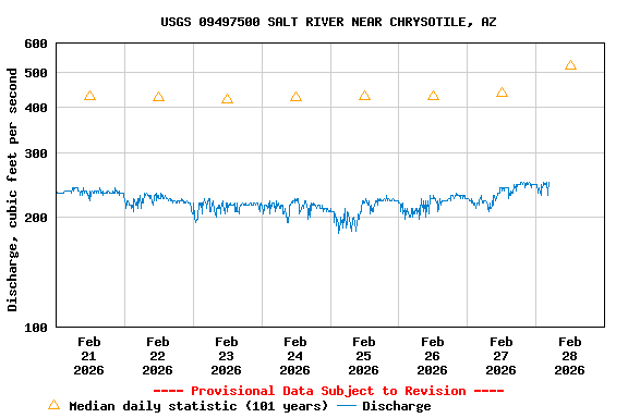
| Min (2018) | 25th percen- tile | Most Recent Instantaneous Value Feb 28 | Median | Mean | 75th percen- tile | Max (1978) |
|---|---|---|---|---|---|---|
| 121 | 219 | 245 | 521 | 848 | 1240 | 4270 |
![]() U.S. Department of the Interior |
U.S. Geological Survey
U.S. Department of the Interior |
U.S. Geological Survey
Title: USGS Current Conditions for the Nation
URL:
Page Contact Information: Arizona Water Data Support Team
Page Last Modified: 2026-02-28 05:24:28 EST
2.8 2.35 vaww02