PROVISIONAL DATA SUBJECT TO REVISION
Click to hidestation-specific text


Summary of all available data for this site
Instantaneous-data availability statement
Temperature, water, degrees Celsius, [AquaTroll] |
||
|
||
![Graph of Temperature, water, degrees Celsius, [EXO]](https://natwebsdww02.cr.usgs.gov/nwisweb/data/img/USGS.10336700.335337.00010..20260213.20260220..0..gif)
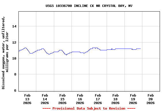
| Min (2023) | 25th percen- tile | Median | Mean | 75th percen- tile | Most Recent Instantaneous Value Feb 20 | Max (1996) |
|---|---|---|---|---|---|---|
| 2.43 | 3.5 | 4.3 | 5 | 5.6 | 10.3 | 14.0 |
Specific conductance, water, unfiltered, microsiemens per centimeter at 25 degrees Celsius, [AquaTroll] |
||
|
||
Specific conductance, water, unfiltered, microsiemens per centimeter at 25 degrees Celsius, [EXO] |
||
|
||
Turbidity, water, unfiltered, monochrome near infra-red LED light, 780-900 nm, detection angle 90 +-2.5 degrees, formazin nephelometric units (FNU), [AquaTroll] |
||
|
||
Turbidity, water, unfiltered, monochrome near infra-red LED light, 780-900 nm, detection angle 90 +-2.5 degrees, formazin nephelometric units (FNU), [EXO] |
||
|
||
![]() U.S. Department of the Interior |
U.S. Geological Survey
U.S. Department of the Interior |
U.S. Geological Survey
Title: USGS Current Conditions for the Nation
URL:
Page Contact Information: California Water Data Support Team
Page Last Modified: 2026-02-20 01:00:31 EST
8.07 6.59 sdww02