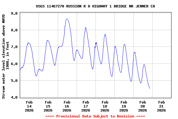
Most recent instantaneous value: 4.51 02-20-2026 20:30 PST
![Graph of Gage height, feet, [NAVD88]](https://natwebcaww02.wr.usgs.gov/nwisweb/data/img/USGS.11467270.229225.00065..20260214.20260221..0..gif)
See this graph on the Monitoring Location Pages
![Graph of Gage height, feet, [NGVD29]](https://natwebcaww02.wr.usgs.gov/nwisweb/data/img/USGS.11467270.241826.00065..20260214.20260221..0..gif)
![]() U.S. Department of the Interior |
U.S. Geological Survey
U.S. Department of the Interior |
U.S. Geological Survey
Title: USGS Current Conditions for the Nation
URL:
Page Contact Information: California Water Data Support Team
Page Last Modified: 2026-02-21 00:41:10 EST
1.5 1.14 caww02