USGS 13068500 BLACKFOOT RIVER NR BLACKFOOT ID

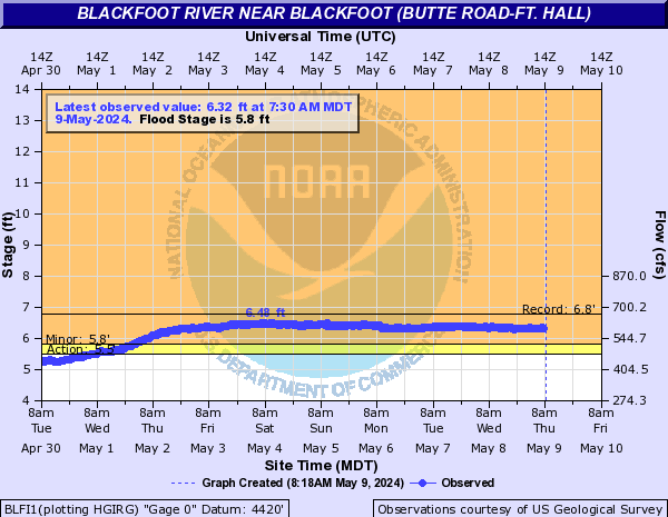
PROVISIONAL DATA SUBJECT TO REVISION

Click to hidestation-specific text
Blackfoot River near Blackfoot, ID - USGS file photo USGS Idaho Water Science Center celebrating more than 100 Years of streamgage Records

> Rating Information

Station is operated in cooperation with:


> NWS River Forecasts

This station managed by the Idaho Falls Field Office.

Available Parameters Available Period
  
2007-10-01  2015-10-15
1987-02-17  2025-12-25
2007-10-01  2025-12-25


 (7)
 

  -- or --


Summary of all available data for this site
Instantaneous-data availability statement

Temperature, water, degrees Celsius
 
-- Data temporarily unavailable for the time period specified --


Discharge, cubic feet per second

Most recent instantaneous value: Ice 12-25-2025   07:30 MST
Graph of  Discharge, cubic feet per second

Add up to 2 more sites and replot for "Discharge, cubic feet per second"

?


Create presentation-quality / stand-alone graph.   Subscribe to WaterAlert      

See this graph on the Monitoring Location Pages


Daily discharge, cubic feet per second -- statistics for Dec 25 based on 60 water years of record more
Most Recent
Instantaneous
Value Dec 25
Min
(1993)
25th
percen-
tile
Median Mean 75th
percen-
tile
Max
(1985)
-- unavailable -- 21.0 60 81 98 105 350


Gage height, feet

Most recent instantaneous value: 2.47 12-25-2025   07:30 MST
Graph of  Gage height, feet

Add up to 2 more sites and replot for "Gage height, feet"

?


Create presentation-quality / stand-alone graph.   Subscribe to WaterAlert      

See this graph on the Monitoring Location Pages