USGS 13077000 SNAKE RIVER AT NEELEY ID

PROVISIONAL DATA SUBJECT TO REVISION

Click to hidestation-specific text
Snake River at Neeley, ID - USGS file photo USGS Idaho Water Science Center celebrating more than 100 Years of streamgage Records

> Rating Information

> NWS River Forecasts

Realtime Gage Height data is provided by U.S. Bureau of Reclamation (USBR) telemetry .

This station managed by the Idaho Falls Field Office.

Available Parameters Available Period
  
1987-07-29  2025-11-02
2007-10-01  2025-11-02


 (7)
 

  -- or --


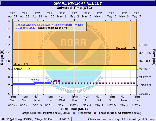
Summary of all available data for this site
Instantaneous-data availability statement


Discharge, cubic feet per second

Most recent instantaneous value: 304 11-02-2025   23:30 MST
Graph of  Discharge, cubic feet per second

Add up to 2 more sites and replot for "Discharge, cubic feet per second"

?


Create presentation-quality / stand-alone graph.   Subscribe to WaterAlert      

See this graph on the Monitoring Location Pages


Daily discharge, cubic feet per second -- statistics for Nov 3 based on 99 water years of record more
Min
(1942)
Most Recent
Instantaneous
Value Nov 3
25th
percen-
tile
Median Mean 75th
percen-
tile
Max
(1972)
51.0 304 375 1290 2320 3030 12700


Gage height, feet

Most recent instantaneous value: 2.01 11-02-2025   23:30 MST
Graph of  Gage height, feet

Add up to 2 more sites and replot for "Gage height, feet"

?


Create presentation-quality / stand-alone graph.   Subscribe to WaterAlert      

See this graph on the Monitoring Location Pages