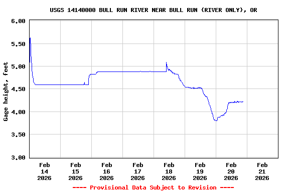
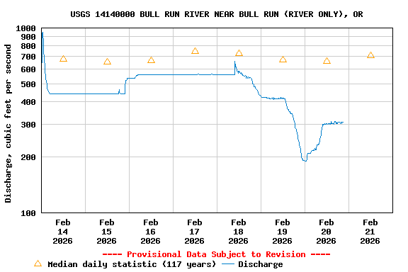
USGS 14140000 BULL RUN RIVER NEAR BULL RUN (RIVER ONLY), OR

PROVISIONAL DATA SUBJECT TO REVISION

Click to hidestation-specific text

Station operated in cooperation with City of Portland.

NOTE: The most current shifted rating for this site can be found at USGS Rating Depot website.
Boating safety tips
Available Parameters Available Period
  
1986-10-01  2026-01-19
2007-10-01  2026-01-19


 (7)
 

  -- or --


Summary of all available data for this site
Instantaneous-data availability statement


Discharge, cubic feet per second

Most recent instantaneous value: 292 01-19-2026   13:45 PST
Graph of  Discharge, cubic feet per second

Add up to 2 more sites and replot for "Discharge, cubic feet per second"

?


Create presentation-quality / stand-alone graph.   Subscribe to WaterAlert      

See this graph on the Monitoring Location Pages


Daily discharge, cubic feet per second -- statistics for Jan 19 based on 117 water years of record more
Min
(1981)
Most Recent
Instantaneous
Value Jan 19
25th
percen-
tile
Median Mean 75th
percen-
tile
Max
(1970)
9.40 292 396 893 1310 1740 7170


Gage height, feet

Most recent instantaneous value: 4.17 01-19-2026   13:45 PST
Graph of  Gage height, feet

Add up to 2 more sites and replot for "Gage height, feet"

?


Create presentation-quality / stand-alone graph.   Subscribe to WaterAlert      

See this graph on the Monitoring Location Pages